RWY28R and the many flight paths
Since inception the north runway project has had several flight paths. Only 1 was used in the original 2005 Environmental Impact Statement, so only that one is legal.

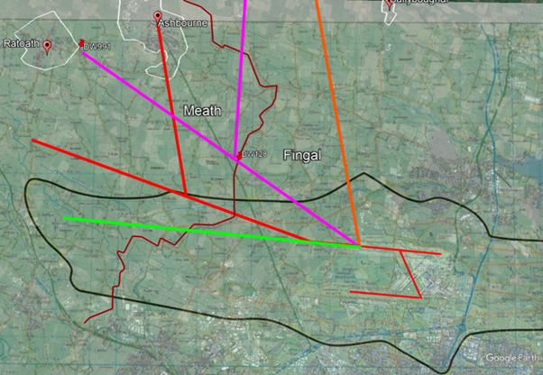
We’ve used Google Earth to display the various flight paths that AirNav and daa have used for planning, consultation and finally implementation.
- The green line was the flight path used to create the original Environmental Impact Statement for the original planning application for the north runway project. The black outline is the resulting “outer noise boundary” from that EIS.
-
The red lines are the routes used in the 2016 public consultation using a 15 degree turn and subsequent 60 degree turn that would place the majority of the environmental impact in Meath. This public consultation took place only in Fingal and the planning application in which these flight paths were used was subsequently withdrawn. The red flight path was never submitted to IAA for assessment.
- When the runway opened daa was “taken very much by surprise” that aircraft followed the orange route over Fingal. They moved very quickly to have AirNav modify the route ensuring the impact is in Meath.
- The magenta lines show the presently operational routes. Note the orange line was moved just over the border to a newly created waypoint DW128 in Meath. This is the only error daa admits to in the entire process and Kenny Jacobs apologized on PrimeTime for this while insisting that the magenta lines are now the “intended route”.
So, the only line that put air traffic over Fingal was a mistake and they’re very sorry, while the illegal flight paths over Meath are intentional. Was this the deal for Fingal County Council to grant the relevant action and remove the night flight limits?
So how far off track are these aircraft?
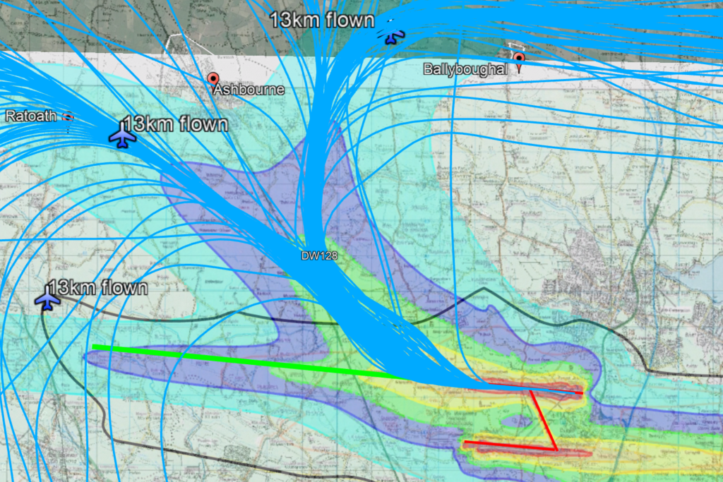
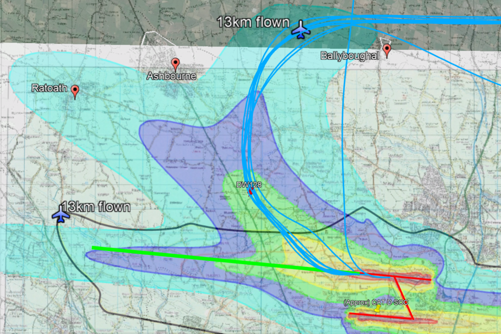
Let’s look at where they were supposed to leave the “outer noise boundary” when Dublin Airport Authority was granted permission to build the runway. On the left of the map above you’ll find an airplane, 13km from the end of the runway. Aircraft were supposed to follow the green line and begin their turn having already climbed straight ahead at maximum climb efficiency putting them at this point when they exited the noise zone.
On the routes in use today, 13km is in the top right, approaching Ballyboughal. About 60% of departures use this early turn to head east and leave the “noise zone” after about 3.5km meaning they are much closer to the ground and the noise zone now looks like the coloured areas. These coloured areas are what daa now calls the “permitted noise zones” despite they are not even close to their granted planning permission.
Bottom line: On this track, after 13km flown the aircraft are 12km from where they are supposed to be.

The rest of the traffic heads out over Ratoath. Of course with low altitude turns at the beginning of the track they are at lower altitude because if you’re turning you’re not climbing as well. On this track at low altitude right on top of 12,000 people instead of over empty fields and solar farms they are “only” 5km from where they are supposed to be.
In summary, daa has ignored Condition 1 of their planning permission for the north runway which requires them to stay within the noise footprint of the original Environmental Impact Statement. 300+ flight every day are flying over the homes of 30,000 people instead of over empty fields and solar farms. Calling the current routes “always intended” is simply not accurate. The sad thing is that it can be fixed and the damage daa and AirNav are doing to these people is completely unnecessary.

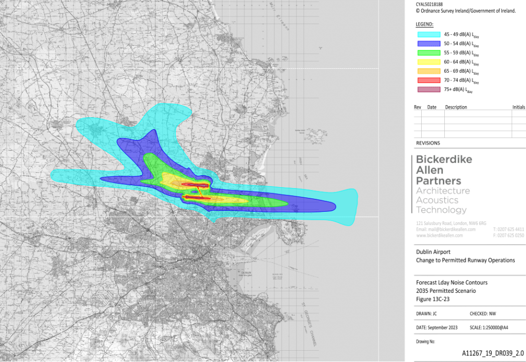
This is the daa noise zone map used in the overlay above. The dB levels in the key are calculated in such a way as to make them as small as possible. When for example, a 68db(A) noise event happens 300 times each day, the daa averages that with the normal background noise over 16 hours and calls it 45-49db(A). This makes sense if you’re willing to accept that having for example an engine running in your back garden every 90 seconds at 65db(A) is the same as having the constant sound of something like a stream flowing by all day long at 45db(A).
